
Swag and the Death Ray
An old guide to getting unlost

This week's Substack has a special guest, my dad, Pete Kirkpatrick, a man who made a career out of finding his way around the mountains, as well as finding those who had failed to do so, having spent decades in the RAF mountain rescue (my podcast with him is here). His words were spurred on by my very nerdy post of pacing beads, but are far more interesting than mine could ever be!
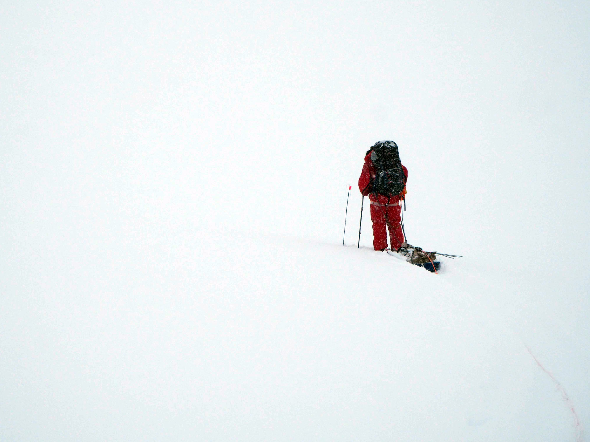
I’ve been really lucky to spend many years of my working life in the mountains of the UK, and occasionally elsewhere in the world. In the 1960s, when this romantic affair began, one navigated with a protractor, a piece of string, a military prismatic compass, and a 1-inch-to-the-mile OS map. My memory is of basically straight-line walking, not much faffing around, and lots of “where the £&@¥ are we?” moments. By the time I left the serious mountain navigation stuff in the nineties, I could micro-navigate to an amazing degree—one my youthful self would have never believed. This rise in ability was driven by periods of teaching “navigation” to others, getting lost occasionally, and loving the business of moving through the hills feeling, most of the time, that I knew where I was.
Moving on to a few weekends ago: I was walking on a windy and misty Welsh hill with an old friend. We chatted about some of the unusual navigation techniques we knew and posed the question: in this age of handheld navigation aids, do these old methods still have value? And what other stories or hacks have other folks used, or do they still recall?
Setting the Scene
So, my post is about my memories of the serious end of navigation, not the basic skills that I assume the reader already possesses. What is serious navigation? I’m thinking it’s when the consequences—for you and others—of getting lost, delayed, or having other problems are also serious. Is ego damage serious? Now, that’s another piece I’d love to write sometime.
At the other end of this imaginary consequence scale could be: “Fuck it! Let’s get lost and just enjoy it!”
Another expanded scale in terms of techniques and knowledge around navigation, from “Not bothered much” to “Really bothered,” is:
* Nothing – just follow others.
* Take a map – show an interest.
* Take a map and a compass – showing more interest.
* Play with some form of planning – Naismith etc.
* Start to gain and use timed legs.
* Increase map and ground reading and walking skills.
* Start to pace and understand what is required.
My recollections will focus mostly on the timing and pacing end of that scale, which helped me get close to a standard of 5% error when pacing or walking on a timed leg. But, more importantly, it helped me avoid any dire consequences of being lost.
Timings
I found with timings that, as I became more experienced, I didn’t need to do all those twiddly bits involved with Naismith etc. The “timings” just popped into my head after a quick look at the map. This was, I guess, an outcome of working in a mountain environment for a long time—it was drilled down into speed and motion in the hills. Let’s do some drilling!
Timing - the Walking Bit – Non-ascending
These were my discoveries about timing:
We all have a natural cruising walking speed that changes according to the situation, weather, morale, rucksack size, fitness, and blah de blah... We can all go quicker if the situation requires it; some can go quicker than others for longer.
It took time to develop a sense of pace against Naismith’s criteria of 3, 4, 5, or 6 kilometres an hour and to sense how fast or slow you were walking.
How to do that
Lots of experimentation. I recall setting out a precise 100-metre flat walk-up-and-down research area. I used it to experience what walking 100 metres at 2 minutes, 1:30, 1:12, and 1 minute feels like, with light or heavy loads. An interesting test was to get someone to walk with you and intentionally go at different speeds. Your challenge was to name and voice that speed. For example: “5, 5, 5, and a bit more. 6, 6, 6, 5, 4.5, 4, 4, 3.5, 3.”
My cruising rate was 5k per hour. My fast rate was 6k. Average group speed 4k. What’s your experience?
Pacing
I also became quite geeky in that 100-metre worksite, working out how many paces you take at different speeds for that stretch. I found my baseline was 65 right-foot steps at 5k, which rose to 72 at 4k and dropped to 60 at 6k pace.
At my normal pace, if I freeze mid-stride, the distance between my front heel and the toe of my rear foot is about the same size as my actual foot. Once I had discovered that, when I walked over difficult ground and took time to see what the foot gap was, I had useful data. For example, in deep snow or heather, my pace rate went up to 120 paces per 100 metres.
Keeping Count
A continual challenge with pacing is remembering how far you have come. I tried stones, beads on my compass string, hand clickers, and speaking out loud. Looking back, I found that if I lost count, I wouldn’t fret. I’d just accept it and know my best guess was better than having no clue at all.
“How did you do that?” was a question I once asked a Royal Marine about a calculation he had just performed.
“I applied the Principle of SWAG,” he replied.
“What’s SWAG?” I asked.
“A Scientific Wild-Assed Guess,” he answered.
The Pacing Train
One creation that I used often was the “Pacing Train.” I found that, apart from being a navigational aid, it helped group morale, was inclusive, and was even fun at times, even in extreme situations.
Imagine a long navigational leg that you decide to pace—say, 1200 metres on a certain bearing. As a leader, you then organise the group. The first in line follows the bearing and paces the first 200 metres. The rest of the group lines up behind that person like train carriages. The last person follows the bearing and shouts out useful info to the leader, e.g., “You are drifting left!”
Once the first 200 metres have been walked, the lead person shouts out, “200 gone, 1000 to go!” and steps aside while the train passes. They then take up the “last person” position. The train doesn’t stop; it keeps rolling.
Hands and Arms: The Death Ray
Another favourite was the “Death Ray” technique. Some Mountain Rescue troops recall team members marching across the hills throwing out “death ray zaps,” like a vague salute. It did have its uses, though.
Imagine being dropped off at night in winter somewhere high in the Scottish hills by helicopter. Visibility is poor, it’s dark, and the weather is foul. The basic technique is a horizontal swishing of the arm at shoulder height. You swish away to establish a sense of the horizontal and the imaginary contour line you are on. You send someone away, shouting “up” or “down” so they maintain that same height to a distance where you can take a bearing on them. This doesn’t indicate exactly where you are, but rather where you are not. It allows you to apply SWAG and make a calculated move.
Quick Tips
* Inuit Trick: In extreme wind, cup your hands into a fist shape to manufacture a small “peep-hole” to see through.
* Light Levels: When the sun is setting, measure the “fingers” gap between the sun and the horizon. One finger equals roughly 15 minutes of light.
* The Rule of Ten: Point your finger at arm’s length at an object. Find which eye you need to close to make that finger “jump.” Estimate the jump distance and multiply by 10 for the distance to the object.
* The Glove Trick: In cold conditions, placing a spare Dachstein glove down your trousers in front of your “manly bits” is a real morale boost.
* Walking at Night: Wear your head torch around your neck. It illuminates the ground without ruining your peripheral vision.
My Bottom Line
The hills can be givers and takers of many things. They have been there a long time. They don’t value qualifications or experience. They are just hills. Learn what you can to increase your chances of good memories and happy homecomings. Allow them also to make you feel stupid, unfit, and inadequate. It’s not personal.